Our chosen route - a brief description

Well I have finally got around to publishing a post on our chosen route! Please remember that since I have never been to Kilimanjaro the information on this site was gathered through research on the net and therefore taken as truth and not verified as such personally.
Some information about our planned ascent:
Adventure Afrika distributed the following agenda for us:
Itinerary; Our itineraries are designed to try and incorporate, as closely as possible, the full moon dates, as well as to minimise “fractionating” of work weeks. Herewith our proposed Itinerary for January 2007;
Saturday 13th - Depart Cape Town or Johannesburg
Saturday 13th - Depart Johannesburg – afternoon flight to Dar Es Salam & Kilimanjaro International
Sunday 14th - Climb day #1
Monday 15th - Climb day #2
Tuesday 16th - Climb day #3
Wednesday 17th – Climb day #4 – Midnight Summit
Thursday 18th – Climb day #5 - Descent
Friday 19th – Climb day#6 – Off the mountain and back at Hotel
Saturday 20th - Return to South Africa or on to add on activities
Now I must admit that I had a bit of a blonde moment here, as I did not see the “days acclimatisation” that we discussed at our first (or second) meeting. A bit of a panic and a confirmation call to Thomas confirmed that we are in fact taking a days rest at Horombo for acclimatisation. I have therefore taken the liberty of expanding our itinerary, which now looks as follows and has been confirmed with Adventure Afrika:
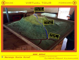
Sunday Marangu gate - Mandara hut : 3-4hours 1800m to 2700m climbed 900m over 6km
Monday Mandara - Horombo hut : 5-6hours 2700m to 3675m climbed 975m over 11km
Tuesday Rest day for acclimatisation - perhaps a visit to Mawenzi Huts (4538m)
Wednesday Horombo - Kibo hut : 5-6hours 3675m to 4750m climbed 1075m over 11km
Wed Midnight Kibo - Gilmans point : 5-6hours 4750m climbed 5681m over 931m ?
Thursday Gilman's - Uhuru Peak : 1-2hours 5681m to 5892m climbed 211m ?
Friday Off the mountain
The route that we will walk
In a nutshell: we have all agreed to embark on a forty-kilometre uphill walk, followed immediately by a forty-kilometre knee-jarring descent. We will start at 1800m above sea level and will climb to 5892m before turning around and walking all the way down again – to boot; we will pay a shit load of money for the honour. As for my part – I can’t wait!
Climb day 1: Sunday
Marangu Gate to Mandara Huts
The first day’s walk is apparently a very pleasant one of about 6km or so, and though the route is uphill for virtually the entire time, there are supposedly enough distractions in the forest to take our minds off the exertion: from the tall and solid Macaranga Kilimandscharica trees with their smooth grey bark to troops of vervet monkeys. In the early stages the path is neat and well maintained, lined with stones and with drainage channels on either side. Gradually, however, the forest closes in on all sides and the mountain’s flowers start to make their appearance by the wayside. A wooded bridge to picnic tables at Kisambioni marks the halfway point of the first day. It would seem that most people stop here for lunch.
After lunch (if we do indeed stop at Kisambioni) the path starts to get steeper and will lead us through the forest past one bridge and then over another into the start of the heath zone. We will start to see the giant heathers (Erica excelsa) on the trail, intermingling with the camphorwood tree, with masses of bearded lichen liberally draped over both; and though the forest will reappear intermittently right up to the Maundi Crater, it’s the spindly heathers and stumpy shrubs of the second vegetation zone, the alpine heath, that will dominate our path on this day. Once we have crossed the second bridge, it should take us about 35 minutes to the Mandara Huts (2700m).
The Maundi Crater – From the Mandara huts, there is a short (15min) walk to the parasitic cone known as the Maundi Crater. The crater is apparently worth the walk for its views east over Taveta and north-west to Mawenzi and for the wild flowers and grasses growing on its slopes.
Climb day 2: Monday
Mandara Huts to Horombo Huts
On this eleven-kilometre stage, we will gain almost a kilometre in altitude, and will say goodbye to the forest and spend the greater part of the day walking through the bleaker landscape of Kilimanjaro’s moorland. If the weather is clear we should get our first really good look at the twin peaks of Kili, the spiky Mawenzi and the snow-capped Kibo. For those of us interested in the fauna and flora – we will start to see the giant groundsels and rather phallic lobelias.
Apparently, our day will begin with a stroll through a monkey forest towards the Maundi Crater. After about fifteen minutes we will leave the forests and enter a land of tall grasses and giant heathers. We will then pass through gently undulating fields that feel (according to some of the net articles) somehow vaguely prehistoric. Following on upwards along the north-west slope directly towards Kibo, we will see Mawenzi peering over the horizon to our right and Kifunika Hill (the main water source for many of the villages) on our left. We will continue up the north-west slope until we reach the Horombo Huts.
Climb day 3: Tuesday (Acclimatisation)
Once again this is just my guess as to what we will be doing, Thomas is going to arrange an informal chat with Adventure Afrika later in the year to confirm our route.
However the chances are good that our guide can lead us on the northern route (aka Mawenzi Route) past the Zebra Rocks and up to the Mawenzi Huts at about 4600m. Not only will this exercise allow us to cope with the thin air of Kibo later on, but we will also get to see the view of our ultimate destination across the Saddle, and it is near enough to allow us to return to Horombo for a late lunch and good rest before day 4. I am up for this one – if my legs and lungs allow that is!
Climb day 4: Wednesday
The path to Kibo from the Horombo Huts now divides into two; the most common route is the southern (left-hand) route. It will be great if Simon does take us on this route as we will have already done large portions of the northern route during our acclimatisation day. The southern path is eleven kilometres in length and is apparently rather steep at first as it winds its way up through the thinning vegetation of the moors. Looping north, just under an hour after leaving Horombo we will come to the tiny mountain stream known as the Maua River (3940m). This is the last clear water on the trail, from here on it apparently gets very brackish.
The terrain gradually levels out after Maua. Still bending north, the path leaves the scant vegetation behind for even more barren terrain. The beginning of the approach to the Saddle is marked by the Last Water Point sign. The saddle is the dry, barren terrain separating Kilimanjaro’s two major peaks. The landscape to follow is rather flat, extremely windswept and very dramatic. The path loops north between between the Kibo summit on your left and the Middle Red (a small parasitic cone) whose western slopes shelter trekkers from the often howling wind and usually provide the venue for lunch.
After lunch we will continue northwards across the Sadcdle; apprantly it is a weary trudge on a steadily inclining path to Jiwe Lainkoyo, a former campsite with some toilet huts and a huge boulder. This is also the meeting point between the two main paths from Horombo. Once we leave Jiwe the path turns sharply westwards toward the Kibo Huts. Thought the huts will appear close, we will still have more than an hour of walking from Jiwe, and it’s a tough walk too – a gradual but relentless uphill slog. The huts themselves are apparently very basic, built of stone and rather chilly. The huts are at 4750m and are five hours away from Gillman’s Point.
posted by Sandra Ackland @ 11:12 PM
0 comments
![]()